

July 2024 Update
Upcoming Public Meetings
Camden County, in cooperation with the City of Camden, Pennsauken Township, and Winslow Township will be holding two public meetings to inform residents on local segments of the Camden County LINK: the proposed 34-mile regional trail from the Benjamin Franklin Bridge to the Gloucester County line at the south end of Winslow Township. Both meetings will include a presentation and boards by the County’s design consultant NV5, to inform residents on the specific trail segments and overall progress of the trail.
Meetings will take place in-person in open house format so interested residents can learn about the forthcoming work. Presentations on the projects will take place at 6:30 PM and 7:30 PM.
Residents who are unable to attend the meetings may view the information below.
Public Meeting Materials:
Segment 1A, located along the Cooper River in the City of Camden and Pennsauken Township:
July 29, 2024 | 6 PM – 8 PM
Camden County Historical Society, 1900 Park Boulevard, Camden
Segment 1E, located in New Brooklyn County Park in Winslow Township:
July 31, 2024 | 6 PM – 8 PM
Star Building, 100 Erial Road, Sicklerville
Overview
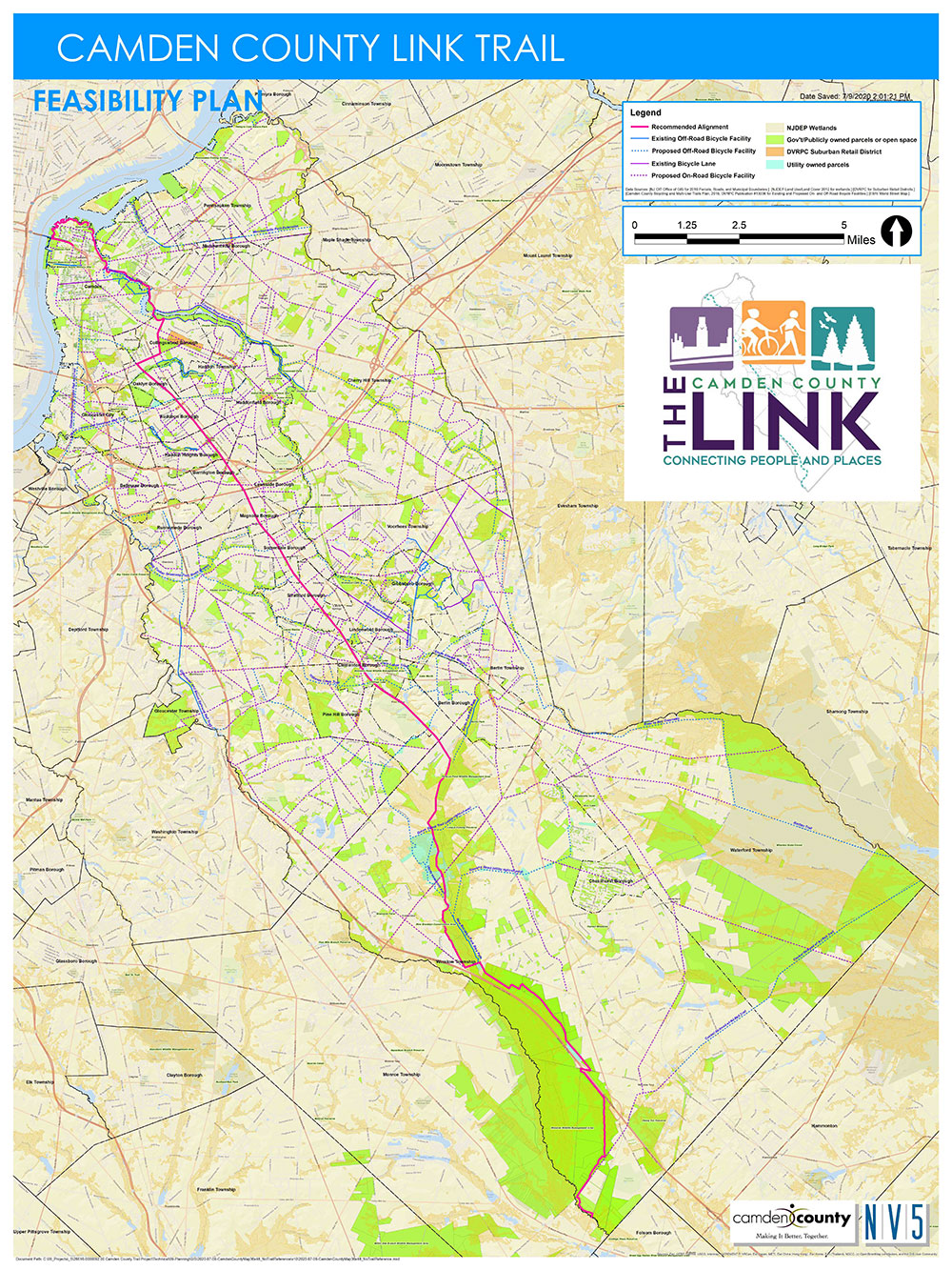
The Camden County Link is a planned 34-mile multi-use, off-road trail designed to serve as the “spine” for a County-wide trail network.
In 2017, the County completed a feasibility study for this spine, known at that time as the Cross Camden County Trail. The result was a trail alignment that travels through seventeen municipalities from the Benjamin Franklin Bridge in Camden to the Gloucester County line in lower Winslow Township. Along the way, the trail will travel through urban, suburban, and rural environments connecting many municipal and County parks and several downtown business districts. In addition, the trail will provide users with the opportunity to access hundreds of acres of public open space in Winslow Township. The feasibility study also identified the benefits of the trail to the local economy and the improved health of our residents. (See below for a link to this study and accompanying appendix).
Previous Public Meeting Materials
- 2020 Segment 1B (Audubon & Haddon Heights) Public Meeting
- 2020 Segment 1C (Somerdale & Hi-Nella) Public Meeting
- 2020 Segment 1D & 1E (Winslow Township) Public Meeting
A number of drone videos have been produced identifying the preferred route for the trail through the entire length of the County. Links to these videos can be found below.
The next phase of the development of this trail has begun.
In 2017, the County was awarded a $200,000 Recreational Trails Grant by the Delaware Valley Regional Planning Commission to begin design work on a more than four-and-a-half-mile segment of the trail in Winslow Township.
In 2018, the County, with the assistance of the Rails to Trails Conservancy, was awarded a $1.2 million TAP grant for construction of the first new segment of this trail. This approximately one-mile segment will be built between East Atlantic Avenue and the Conrail railroad tracks in Audubon and Haddon Heights.
In 2019, the County, through an RFP process, awarded a $4,579,540 contract to NV5 to design approximately two thirds of the 34-mile trail over the next several years. Completing the design will allow the County to apply for State and Federal grants for construction. The County has prioritized this design work, identifying segments as Priority 1, Priority 2, and Priority 3.
In 2021, Camden County was awarded a $1 million grant for the Cooper River Bridge and a $3.2 million grant for a separate bicycle and pedestrian bridge over Route 130 (Crescent Boulevard) at Cooper River Park.
The first series of public meetings to present preliminary design plans for Priority 1 trail segments was held virtually in 2020. See the hyperlinks above for more information.
More public meetings will be held in the future for other trail segments as the design advances.
Drone Video 1 Camden & Pennsauken
Drone Video 2 Collingswood & Haddon Township
Drone Video 3 Oaklyn, Audubon & Haddon Heights
Drone Video 4 Barrington, Lawnside & Magnolia
Drone Video 5 Somerdale & Hi-Nella
Drone Video 6 Stratford, Laurel Springs & Lindenwold
Drone Video 7 Clementon and Pine Hill
Drone Video 8 Winslow Township
Drone Video 9 Entire length of Trail